With recent events with the US Navy alliding with commercial ships and people asking if the blue ship could have been hacked, it's time to dust off the old notes. I've wanted to write a paper (or 10) about this topic since about 2005. I might as well try in blog form to get out what I have.
First some old material material...
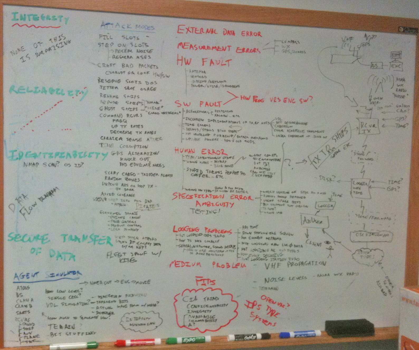
Back in 2012, I made this blog post: AIS SECURITY AND INTEGRITY. My whiteboard from that exercise:
http://schwehr.org/blog/attachments/2012-11/20110429-ais-security-integrity.jpg

And I started a doc for a paper and here is what I had as of 2010:
Integrity and Security of the global maritime Automatic Identification System (AIS)
Kurt Schwehr
In 2006, the several people in the US Government encouraged me not to write a paper on the security of AIS. I have concluded that it is important to discuss these issues in the open. Security through obscurity is not a good solution. Many people have already thought through how AIS is vulnerable, but there has not been a source of information to the typical mariner or marine manage that lays out the issues. AIS is an effective tool for maritime activities, but care needs to be exercised when using or trying to improve the system. Changes to how AIS is used in real-time or post processed for analysis of water way activities can have unexpected consequences some of which can have negative environmental and economic impacts or put the mariner at greater risk of harm.
Unsorted
- Bandwidth limitation
- No official standard for logging with metadata (especially time) and transmitting over internet and other secondary channels
- Limited reliable transmit capability
- MKD is horrible and error prone. Often not located in an easily visible portion of the bridge
- AIS might not be integrated into ECS and/or ECDIS systems
- No standards for autonomous vessels
- Repeaters can quickly flood the AIS channel
- Incorrect understanding by mariners and data analysis of what AIS means
- Poor monitoring of AIS receiver networks
- Larger messages have a higher probability of packet collision
- Patent encumbered technology
- Regulatory environment - not much room in the United States for experimentation and research
- Can you issue penalties for behavior recorded only in AIS received reports?
- Should fishermen install or block AIS on their vessels? The proprietary knowledge of where they fish.
- Attacks targeting vessels based on AIS. Is this really any worse that without AIS? e.g. Boston’s north LNG terminal.
Time and Positioning
- What time does the position translated relate to?
- Partial timestamps in packets and accuracy only to the second
- RAIM seems like it is not really useful to indicate position accuracy
- Offset issues between the ship reference point and the GPS reported by Pilots
- Knowing where your receiver is located when getting data from networks such as NAIS
- Timestamping of received messages that happens down stream may get very confusing.
- GPS errror example from 2009 NOAA review in portsmouth NH
Radio noise and propagation issues
- NOAA weather radio transmitters and other systems that put energy into the AIS spectrum
- Inland use of the same spectrum
- Noise on the GPS channel and solar issues
- better propagation conditions that tunnel packets between cells will cause interference
- currently not enough satellites and ground stations to give realtime global coverage
Receiver and Transmitter issues
- Weak checksum scheme may create valid packets
- Cheap receivers might decode noise as valid
- Single channel receivers will miss half of the message traffic
- VHF propagation issues prevent seeing distance ships most of the time
- Transmit antenna height and power greatly matter for receive potential
- For remote receivers, how do you know they are working if you aren’t sure there are transmitters in the area. E.g. Antarctica (or little bay)
Class A or B units
- - Turning off the unit (trivial to accomplish) or power failure
- - Loss of GPS - antenna, urban canyon, multipath, kalman filter problems
- - Unintentionally mis-configured devices. Human error, system failure, sensor failure, antenna failure
- - Intentionally incorrect devices. How to confuse people. What can you reprogram on a Class B?
- Inability to match to an exact vessel in other registries
- broadcasting bad time
- Bad carrier sense in Class B
- Long term scalability of the number of units that can be on the channels
- How good is the self reported heading, ROT, speed? Which sensor is being used? Does the GNSS have any extra capabilities beyond just the traditional GPS? WAAS, Diff, satellite transmitted corrections like CNAV, RTK?
Transmissions by non-blue force (e.g. normal operations)
- Not encrypted - Even addressed messages are received by all hardware
- No cryptographic signature capability - impossible to assure identity
- Specifications such as Circ 289 require people keep already public data protected
- No way to TX position securely in areas with pirates
- There are free and pay networks that will give realtime AIS to anyone. Not everyone is willing to acknowledge this.
Blue force encrypted transmission
- Lack of comm state in message 8 makes scheduling of slots difficult for other vessels
- Direction finding may still identify the location of military or law enforcement vessels with COTS receivers
- Is the encryption really secure?
- It is unclear what the policy for switching between silent, secure, and normal modes
- Is the encryption really secure?
- The DAC/FI is not always the same and may infact be random
SAR and other aircraft
- Broadcasting at altitude can span many cells and cause wide spread interference
- May hear other cells and be less able to receive (solvable as evidenced by satellite)
Basestations and ATONs
- reserving slots to consume bandwidth
- telecommand to change reporting rates
- changing the frequency of AIS units (see USCG announcement)
- sensor failure for met hydro might go undetected or predicted not noticed as such
Software or hardware units that are not type approved
- Accidental or intentional interference on slots
- Ghost fleets of fake ships - Spanish?
- Transmitting incorrect info for correct ships
Software and hardware QC/QA problems
- Paywalled specifications
- Closed testing
- Connector design problems
- Very few ports have knowledge, means of detecting, and technicians to correct bad or misconfigured AIS units. SF is an exception
- Complicated specifications lead to errors in implementation
- Ambiguous message definitions because of the lack of use of a formal language to define messages.
- Lack of evolution in some specifications have led vendors to innovate on their own with incompatible and/or undocumented changes (e.g. Ohmex)
- Units are inconsistent in between messages. This should be uniform for the network and configurable at the presentation interface when displayed
- No official catalog and registry system where countries can submit their regional messages
Possible improvements and solutions
All is not lost! AIS is an effective tool for many maritime tasks and likely is making the job of safe navigation much easier. The system as it stands is much better than in the 1990s. Ships now know more of the names of ships around them so that when they call on VHF, they know who to address, they can get better directional information
- Transmitting on other frequencies (and possibly coding schemes)
- I-AIS standards
- Best practices documentation for design of new messages
- Open and free documentation and open certification processes
- Define international standards for raw logging and transfer with JSON and XML messages between applications
- Better suggestions for monitoring receiving integrity
- Explicit documentation on how to calculate time to go with a position
- Best practices for receive networks
- Watch standers guides need to include sections on the configuration, maintenance, testing, and use of AIS data to make sure they are transmitting correctly and properly interpreting/using AIS data. e.g. update rate is not on any AIS displays that I’ve seen
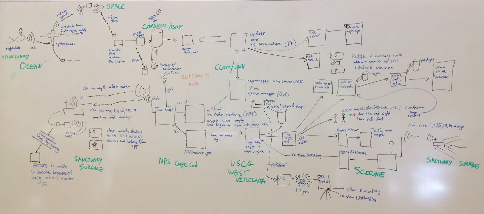
What does one component of AIS look like?
This is a sketch of what the whale alert system looks like at a high level back in 2012.
Sigh... I haven't written a follow up to Part 0 yet.
ReplyDelete